Reality in WY shows lie in oil and gas industry propaganda
We’ve all seen on TV and printed ads how sensitive about the land the oil industry is. They drill many wells from just one pad, avoiding surfance disturbance. If the land cannot bear any suface occupancy, they drill at an angle under it (called “directional drilling”).
Yes, they can do these things, just like it shows on the TV, but the reality in Wyoming and throughout the Rocky Mountain West, is that they don’t do it that way because it is cheaper not to, except for few showcase examples where they can take the media and politicians.
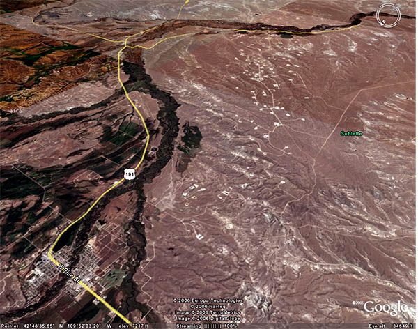
Drill pads on The Mesa (Pinedale Anticline). This is a new gas field, north of Jonah. The town of Pinedale, WY is in the lower left corner. View is to the SE. The deer population on The Mesa is way down.
Where are the animals going? By Whitney Royster, Casper Star Tribune.
Somehow, I don’t think it is drought per se. This decline was also predicted last year in a major study.

Ralph Maughan
Dr. Ralph Maughan is professor emeritus of political science at Idaho State University. He has been a Western Watersheds Project Board Member off and on for many years, and also its President. For many years he produced Ralph Maughan's Wolf Report. He was a founder of the Greater Yellowstone Coalition. He and Jackie Johnson Maughan wrote three editions of "Hiking Idaho." He also wrote "Beyond the Tetons" and "Backpacking Wyoming's Teton and Washakie Wilderness." He created and is the administrator of The Wildlife News.
2 Responses to Reality in WY shows lie in oil and gas industry propaganda
Subscribe to Blog via Email
Recent Posts
- “Stick to the Facts”–How Green Groups Fail to Protect the Gallatin Range May 23, 2022
- Bi State Sage Grouse Reinstated As Proposed Threatened By Court May 19, 2022
- BLM Fails To Protect Public Patrimony Through Renewal of Grazing Privileges Without Environmental Review May 17, 2022
- Conservation Groups Threaten To Sue On East Paradise Grazing Decision May 12, 2022
- Gratitude for National Parks May 11, 2022
Recent Comments
- Maggie Frazier on “Stick to the Facts”–How Green Groups Fail to Protect the Gallatin Range
- Ida Lupine on “Stick to the Facts”–How Green Groups Fail to Protect the Gallatin Range
- Nancy Ostlie on “Stick to the Facts”–How Green Groups Fail to Protect the Gallatin Range
- Jannett Heckert on Conservation Groups Threaten To Sue On East Paradise Grazing Decision
- Rich on Bi State Sage Grouse Reinstated As Proposed Threatened By Court
- Jannett Heckert on BLM Fails To Protect Public Patrimony Through Renewal of Grazing Privileges Without Environmental Review
- rastadoggie on Gratitude for National Parks
- rastadoggie on Bi State Sage Grouse Reinstated As Proposed Threatened By Court
- Megan on Bi State Sage Grouse Reinstated As Proposed Threatened By Court
- Ida Lupine on BLM Fails To Protect Public Patrimony Through Renewal of Grazing Privileges Without Environmental Review
- Ida Lupine on Bi State Sage Grouse Reinstated As Proposed Threatened By Court
- Robert Raven on BLM Fails To Protect Public Patrimony Through Renewal of Grazing Privileges Without Environmental Review
- Martha S. Bibb on BLM Fails To Protect Public Patrimony Through Renewal of Grazing Privileges Without Environmental Review
This looks like an arid region. I wonder what impact these pads are having on local watersheds.
You can see what it looks like by going to the web cams I linked to. There’s the Jonah gas field cam and the Boulder web cam.
It is sagebrush steppe, but beautiful, clear rivers and creeks tumble out of the adjacent Wind River Range into the sedimentary Green River Basin where they muddy up, but there is more sediment going into them now (I think).
In 2004 I camped on a hill about 5 miles from the first of the Jonah wells, and found deep cryptogamic crust between the sagebrush and grass. I was amazed.
At the upper end of the Green River Basin, the land rolls up into the Gros Ventre Bountains. Aspen and pockets of fir appear and finally it is all forest and mountain meadow. This is the wolf and grizzly bear country.
I tried to put up a photo, but I guess that can’t be done in comments