Updated September 23, 2012. This has been a very popular post. I first posted it about 5 years ago, and now I have enlarged and updated it. Ralph Maughan
Ah the Tetons, Wind Rivers, Sawtooths and White Clouds, Wallowas, Bitterroots, Beartooth, and Unitas!
I love all the mountains. I decided to do a major photo essay on the little-known and often little-appreciated ranges of the NW Great Basin. I have left out the Wasatch Range, Ruby Mountains, Schell Creek Range, and Snake Range because I think they are much more prominent in the public’s eye.
Albion Range (Southern Idaho)-

This is an unusual range consisting mostly of just two big mountains, Mt. Harrison and Cache Peak (the highest mountain in Idaho south of the Snake River). The range is just east of Burley and Oakley, Idaho. The amazing Silent City of Rocks is at the range’s southern end.

The Silent City of Rocks at the south end of the Albion Range in Southern Idaho, not far from the Utah and the Nevada borders. Copyright © Ralph Maughan
Antelope Island (NW Utah)-
Antelope Island in the Great Salt Lake is a classic Great Basin range, but surrounded by the Lake. The island is a Utah State Park, and bison, elk , deer, and antelope all have been introduced or reintroduced to the island. It also has coyotes and bobcats. The island is about 20 miles long, and the high point 6596 feet with the mean elevation of the lake 4200 feet.
Antelope Range (White Pine County, Nevada)-

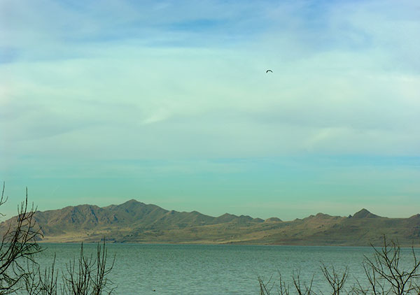
The Antelope Range of White Pine County, Nevada is one of 3 ranges by that name in Nevada. This easternmost one is about 30 miles long, beginning a few miles north of U.S. Alt 93 as a discontinuous series of high hills, and gaining continuity and elevation to the south.The high point is Baldy Peak 9342 feet elevation. The range ends near the northern end of Spring Valley, major Eastern Nevada valley with many springs and much wildlife. The photo was taken at dusk. Copyright © Ralph Maughan
– – – – –
The Bannock Range (SE Idaho)-


More of my photos of the Bannock Range on Google Earth-
Thundercloud from the Scout Mountain Trail
Moose at a watering trough near Crystal Creek
Garden Creek Gap, a water gap of the ancestral Portneuf River
The Blackfoot Range (SE Idaho)-
Wolverine canyon is probably the best known feature in the Blackfoot Range.
Most of the range is private property, so visitor access is not very good to many parts. The topography is complex and varied, although not especially high in elevation. Recently a controversy has developed over a wind farm near Wolverine Canyon. Some folks say it is good clean energy. Others say its size is excessive (10,000 acres) and the proposed 420 foot high windmill towers excessive.

The Black Pine Range (Southern Idaho)-
This is a short, narrow and steep Great Basin type mountain range just north of the Utah border in Idaho.

This photo of the Black Pine Range was taken from the east (near Juniper, Idaho). May 2008. Copyright © Ralph Maughan

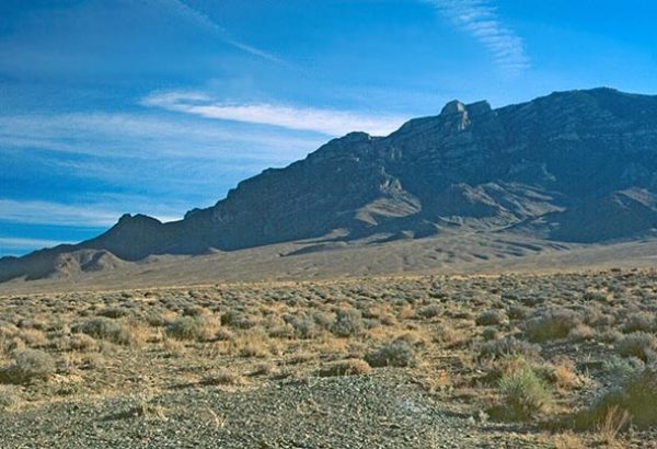
The Cherry Creek Range. Eastern Nevada.

It’s a 50 miles long range with the Steptoe Valley on the east and Butte Valley on the west. High point is 10,542 feet. Part of it was recently designated a Wilderness Area. Photo from Butte Valley (from the west side). Copyright © Ralph Maughan

The Cherry Creek Range from Butte Valley. View to the NE. Photo copyright Ralph Maughan
Google Earth. Cherry Creek Range from near the ghost town of Cherry Creek (actually it has a few people)
The Clarkston Range (Idaho-Utah)-

The Clarkston Range is a 20-mile range on the Idaho/Utah border. High point is 8244 foot Gunsight Peak. This photo was taken in September from Malad Valley (on the valley’s east side). Copyright © Ralph Maughan
Google Earth. Gunsight Peak from Malad Valley
Cotterel Range (Southern Idaho)-
The Cotterel Mountains are a ten mile long range with a very steep east escarpment in places. They rise where the Raft River Valley opens out onto the Snake River Plain and east of the taller Albion Range. They and the Jim Sage Mountains to the south (see about them further below) were once called the “Malta Range.” Copyright © Ralph Maughan.

The Deep Creek Range of SE Idaho

Photo Copyright © Ralph Maughan.
This is a classic linear Great Basin range about 40 miles long with a wonderful crest zone for cross country walking. The north end of the range rises from the Snake River Plain. Arbon Valley is on the east side and Rockland Valley on its west. Copyright © Ralph Maughan. Don’t confuse it with the Deep Creek Range of Utah (below)
Google Earth of the Deep Creek Range. SE Idaho.
North Fork of Bull Canyon.
A limestone ledge on the shoulder of Deep Creek Peak
Bannock Peak. Telephoto from Arbon Valley (on the east side of the range)
Across Arbon Valley to the Deep Creek Mountains. January 2010
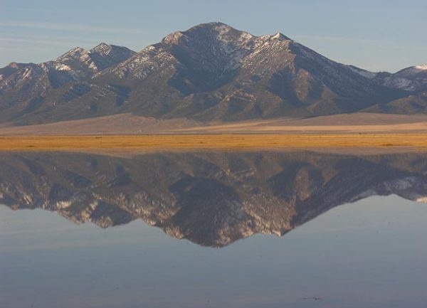
The Deep Creek Range of Western Utah-


The Deep Creek Range of Western Utah, next to the Nevada border, is a stunning, little known range 50-miles long, with two peaks over 12,000 feet! It has a great variety of rock types and canyons. Above are 2 photos in Granite Creek. March 2007. Copyright © Ralph Maughan.
More of Utah’s Deep Creek Range. Google Earth
Budding cottonwood trees. Granite Creek.
Ibapah Peak (12,087′)
Red Cedar Creek Canyon. Very rugged
East Humboldt Range (Eastern Nevada)-

Hole in the Mountain. East Humboldt Range, Nevada. This tall, glaciated range begins at Wells and presents a high rugged profile for about 15 miles until it becomes lower and fades in the Ruby Valley to the south. Although it is a designated Wilderness area, it is little known, especially when compared to the nearby Ruby Range. Copyright © Ralph Maughan

Humboldt Peak , 11,020 feet, is the soutnernmost high peak in the East Humboldt Range of Nevada. Photo Copyright © Ralph Maughan
The Egan Range (Nevada)-
The Egan Range, Nevada is 110 miles long! It is of variable height, but it is always steep. It lies to the SW, West, and NW of Ely on the west side of the Steptoe Valley. Far to the south a semi-detached portion is west of Cave Valley. The photo is at a pond on Duckwater Creek in the Steptoe Valley. March 2007. With two Wilderness areas just designated in the range, perhaps it should not be regarded as obscure anymore. Copyright © Ralph Maughan
The Fish Springs Range (Utah)-


 Fish Springs Range, Utah, is a relentlessly desert range, here with the shadows of the Deep Creek Mountains in the photo above, advancing across the Snake Valley. On the NE side of the Range, there is the Fish Springs National Wildlife Refuge. The range itself is dry and drier. Copyright © Ralph Maughan.
Fortification Range (Nevada)-

Fortification Range of East Central Nevada. Copyright © Ralph Maughan. Photo taken from Spring Valley (in late winter). This rugged limstone range covered partially by scenic volcanic tuff (tremendous cliffs) is 10-12 miles long and virtually roadless. It’s unnamed highest point is 8268 feet. Much of it was recently designated a wilderness area.
These mountains contain a relict stand of ponderosa pine. They are a remnant of a period long ago when the climate was wetter.
Here are some additional photos of the Fortification Range I uploaded to Google Earth.
Sunset in the Fortification Range.
Ledge in the Fortification Range
The Goshute Range (Nevada)-

The Goshute Range from the east in Nevada near the Utah border. This is a N/S 30 mile long range with no clear distinction between it and the Toano Range to its north. The range is variable, about 7000 to 9000 feet high. It is notable as one of the world’s great raptor viewing sites in the fall (from the top of the range). Copyright © Ralph Maughan
– – – – –

Granite Range (Nevada)-
The Granite range of northeastern Nevada is an odd range of granite knobs about 15 miles long, south of Jackpot, Nevada (northern Nevada, not far from Idaho). The range has “bookends” of higher peaks of different rock on its north and south ends. Photo copyright Ralph Maughan.
– – – – – –
Grant Range (Nevada)-
Blue Eagle Mountain (above) rises almost a mile from the desert floor of Railroad Valley. However, the high point of the range, Troy Peak, is 1300 feet higher. This is a seldom visited, bold range of huge cliffs, with a Wilderness area around Troy Peak in East Central Nevada. Despite its great height, water is rare due to the porous limestone. Copyright © Ralph Maughan.
Grouse Creek, Goose Creek and Dove Creek Ranges (Utah-Nevada-Idaho)
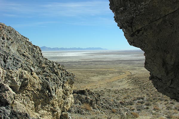
Photo: the Great Salt Lake Desert from the southern end of the Grouse Creek Range, Utah. March 2007. The Grouse Creek Range. Copyright © Ralph Maughan
There is a surprisingly large area of uplands on Idaho/Utah/Nevada border. This includes the Raft River Range as well as the South Hills (see both below).
Three other little known ranges from 15 to 40 miles long run parallel to each other, separated by creeks which serve to name the ranges. From east to west are the Dove Creek Range (in Utah), the Grouse Creek Range (in Idaho and Utah), and the Goose Creek Range in Utah and Nevada.
This Grouse Creek Range is similar and adjacent to the Goose Creek Range and Dove Creek Range.
The Grouse Creek Range is the longest of the three ranges, beginning just south of Oakley, Idaho (there named “Middle Mountain”) and marching south all the way to Utah state highway 30 which crosses just north of the Great Salt Lake Desert/Salt Flats. It becomes increasing arid in its southern portion (see photo above).

Southward along the crest of the Dove Creek Range from near Dove Creek Pass. © Ralph Maughan. Photo May 14, 2008.
Jim Sage Hills (Idaho)-

Here are The Jim Sage Hills of southern Idaho (from the foothills of the Albion Range). These “hills” are a ten mile long extension of the Cotterel Range (see above), but are much less developed. The Western Watersheds Project saved them from “vegetative improvement” by the BLM which would likely have turned them into range with little on them but cheatgrass. Copyright © Ralph Maughan
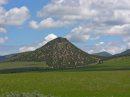
Knoll Mountain (Nevada)-

Knoll Mountain, Nevada. At dawn near the crest of Knoll Mountain, a short, bald range just SE of the Granite Range. Photo May 2006. Copyright © Ralph Maughan.
Maverick Springs Range (Nevada)-

Maverick Springs Range and Ruby Lake, Nevada. Overshadowed by the famous Ruby Range in Nevada, the much lower Maverick Springs Range rises to the east of Ruby Lake National Wildlife Refuge (in photo). Copyright © Ralph Maughan.
Newfoundland Range (Utah)-

The Newfoundland Mountains. Copyright © Ralph Maughan from the northwest, looking across the Great Salt Lake Desert. This range, although not high and surrounded by mud flats of the Great Salt lake, can be seen for many miles (esp. the high point, Desert Peak), but is it rarely visited. It is rugged and has some interesting rock erosional features. No water reliable water. Bighorn sheep were reintroduced to these mountains in January 2008.
North Hansel Mountains (Idaho)-

The North Hansel Mountains are a highly dissected range between Idaho Highway 38 and Interstate 80 northeast of Snowville, Utah. The most unusual thing about these mountains may be large number of earthquakes that occur under them and adjacent Pocatello Valley to their east (this is not the site of the city of Pocatello, Idaho). Set Google Earth to show earthquakes and you will be impressed. Copyright © Ralph Maughan.

The North Hansel Mountains a few miles north of Snowville, Utah in southern Idaho. Copyright © Ralph Maughan. Photo from mid-May 2008.
Pilot Range (Nevada-Utah)

The Pilot Range runs N/S right along the Utah/Nevada border, and is noted mostly for tall Pilot Peak (10716 feet elevation), a landmark for wagon trains heading across the Great Salt Lake salt flats. Here is a lower part of the range near its north end, taken from the Tecoma Valley in Nevada. March 2007. Copyright © Ralph Maughan

Pilot Peak from Pilot Valley (from the SW). Photo Copyright © Ralph Maughan. May 2008
Pleasantview Hills (Idaho)-

The Pleasantview Hills (here 18mm wide-angle from Arbon Valley) seem like an attractive possibility when you study the map and think of places to go. Also called the “Blue Spring Hills” on some old maps, they have a pleasant aspect from their west side (Arbon Valley, 25 miles south of Pocatello, Idaho.


Google Earth photo of Wood Canyon in the Pleasantview Hills. This is the kind of regeneration that can happen when a grazed out canyon is closed to grazing for a few years.
The Pocatello Range (Idaho)-
The Pocatello Range is on the east side of Pocatello, Idaho. The range roughly “L-shaped” and about 20 miles long, beginning on the Ft. Hall Indian Reservation at the north, and to the south it makes a 90 degree turn at Portneuf Gap and runs 10 miles eastward to merge into the foothills of the Portneuf Range at the town of Inkom. It is a low range with a steep west face. On top, however, it becomes much better watered and consists of rolling uplands and gentle mountains like Moonlight Mountain.
The area on top is filling up with country homes and some controversial sub-divisions, although the decline in livestock grazing has actually led to an increase in wildlife, especially moose.
The Pocatello Range in winter a few miles north of Pocatello. Photo Ralph Maughan

Pocatello Range near Inkom, Idaho. February. Photo copyright Ralph Maughan
Portneuf Range (Idaho)-

The Portneuf Range from beneath the basalt cliffs near Marsh Creek in SE Idaho. This 80 mile long range begins at the north on the Shoshone-Bannock Indian Reservation and runs south, forming the east side of Marsh Valley and ending near Red Rock Pass (the outlet of the catastrophic Lake Bonneville food 14,000 years ago). Photo Copyright © Ralph Maughan

The southern part of range is mostly Idaho state school land, not so high or rugged, and some overgrazed. Copyright © Ralph Maughan.
More photos of the Portneuf Range
Autumn in Big Creek Canyon
Lupine and wyethia (mule’s ears) in Pebble Basin
Aspen and fir in the southern Portneuf Range
Cliffs on the face of Snow Peak
Raft River Range (Utah-Idaho)-

The Raft River Range is very unusual because it runs from east to west, instead of the general north to south that is typical of the Great Basin ranges as well as the Rocky Mountains. This is a moderately tall and fairly large, generally flat-topped uplift on the Idaho/Utah border, not far east of Nevada.
Samaria Mountains/West Hills (ID-UT)

The Samaria Mountains/West Hills. The view here is to the NE from the shoulder of Samaria Mountain. This range marks the west side of Malad Valley, rising abruptly south of the Pleasantview Hills. Copyright © Ralph Maughan. The higher northern part of the range is in Idaho, and the lower part which ends near Tremonton is in Utah (here it is generally called the “West Hills”). Samaria Mountain is about 7700 feet elevation, and it runs E/W, contrary to the rest of the range which runs N/S. If you view the area on Google Earth you find it has a very large number of small to moderate earthquakes and do the nearby Hansel Mountains.
The scenic repetitions of slopes of the West Hills (Samaria Mountains). Copyright © Ralph Maughan. We have just learned that the BLM wants to clear out most of this vegetation, which is not commercial forest, under guise of fire control, but these trees do not extend to the edge of nearby communities.
Silver Island Range (Utah-Nevada)-
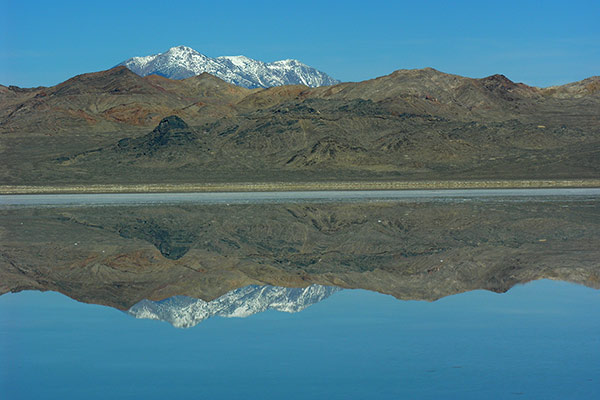
The Silver Island Range on the Utah/Nevada border from the Bonneville salt flats (just a little moist!). Pilot Peak is in the distance. Copyright © Ralph Maughan. This is a frequently photographed range (as an unnamed background), but it is rarely discussed.
The South Hills (south of Twin Falls, Idaho area)-
The South Hills (a.k.a. Twin Falls Hills), Idaho is a vast hinterland of rolling ridge uplands, often cut by deep basaltic canyons. They extend from a few miles south of the city of Twin Falls (also nearby Burley, Idaho) southward for about 50 miles into Nevada where they fade into other obscure topography. Copyright © Ralph Maughan.
It is a broad uplift from 15 to 30 miles wide. It is not typical of Great Basin mountains. While not impressive on the skyline, once you are in these “hills” they seem to go on forever with numerous poor roads leading to all kinds of obscure places. The generally basaltic composition of the rock indicates that this is a transition zone between the Great Basin and the Columbia River Plateau to the west. I think of them as the westernmost of the Idaho ‘s Great Basin mountains. Copyright © Ralph Maughan.
This mountain range is so odd, I can’t think of any examples to compare it to.
In August 2012, a hundred thousand acres of the wildlife valuable east slope to the hills burned in a fast moving wildfire. The long term effects are, of course, not known.

Photo on Hudson Ridge, a plateau in the South Hills. Google Earth.
Little Cottonwood Canyon, one many many basalt canyons that break the east side of the South Hills.
– – – – – –
Sublette Range (Idaho)-

A mountain in the Sublette Range. This Idaho range rises out of the Snake River Plain and runs southward to about the Utah border. It is not especially high, and has the narrow ridgelines so typical of a Great Basin Range. It is somewhat unique in that is not a narrow linear N/S range, and it is high dissected — many lesser ridges and canyons, giving one inside in range the impression of being in a much larger area. Although it is somewhat overgrazed, it is well vegetated compared to many nearby ranges, especially to the south. Some portions have beautiful wildflower displays in late May and early June. The range is on the west side of Rockland Valley, Idaho. The town of Rockland is small. Larger American Falls, ID is about 10 NE of the range’s beginning. Copyright © Ralph Maughan.

June is green in the Sublette Range. Copyright © Ralph Maughan.
Interstate 84 runs along much of the Sublette Range’s west side. There are no towns adjacent to its west.
– – – – –
Toano Range (Nevada)-

The Toano Range from the Pilot Creek Valley, Nevada, looking west. This range seems to be an arbitrary name for the northern part of the Goshute Range. There is an obvious break in mountain ranges at Silver Zone Pass through which Interstate 80 passes, but it is called the Toano Range to both the north and south of this low pass. Copyright © Ralph Maughan.

The Toano Range in the foreground with much higher Pilot Peak (Pilot Range) in the background. Photo from the Goshute Valley, Nevada. Copyright © Ralph Maughan.
Google Earth photos:
In the backcountry on the NE side of the Toano Range.
Toano Range a few miles from Silverzone Pass
– – – – –
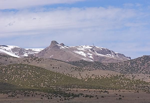
White Pine Range (Nevada)-

The White Pine Range of southwestern White Pine County rises near the north end of big Railroad Valley. Photo Copyright Ralph Maughan. It is a tall and often very rugged range, mostly made of limestone. Prominent high points are Mt. Hamilton (10,745 ft, 3275 m), Duckwater Peak (11,188 ft, 3410 m) and White Pine Peak (10,182 ft, 3103 m). Currant Mountain (11,513 ft, 3509 m) is the high point of the range. Despite its obscurity, parts of it are now protected by two wilderness areas. One is at the north end and the other at the south. The middle part of these mountains is substantially lower and less rugged.
Comments
Ralph,
Great pictures. I used to explore these ranges when I lived in SLC. How fun is it to hike in these obscure ranges?!!!:)
Thank you, Ralph – this is fantastic! And why am I still here in town, typing this???
I loved the Samaria north face mountain shrub/brush/tree striping photo, and don’t think the slopes are repetitious at all! And the colors of the Jim Sage photo.
The Toana-Goshute Range break is curious. It shows up on BLM Land Status Maps, and is also how BLM broke out Wilderness Study Areas there. This winter, I had asked a Nevada geographer, and he said the same thing you did. I’ve thought the naming could be an artifact of early trails, as there is a historical sign pointing to a Peak (and perhaps an early Trail) south of Silverzone Pass.
Ther Granite Range just south of Jackpot is fantastic. Anywhere else, its granite boulder piles, especially along the ridge, would be a small National Something. Elko BLM has long tried to ruin it with livestock water developments and extreme abuse. It is part of a 300,000 acre or so Salmon River allotment (from when Salmon used to head south towards Nevada), that is sort of like the Pleasantview allotment In Idaho, a large Grazing Association grazes the whole area, and it is a dumping ground for all manner of backyard cows AND domestic sheep, too, from Twin Falls country. These “grazing association”-type allotments are truly the “Tragedy of the Public Lands Commons”. It, and nearly all the other rocky ranges you pictured, could have bighorn sheep if domestic sheep were not grazed somewhere on or near them on public lands. Of the ones you pictured, how many do???
KT,
Your post reminds me I have to put up the Pleasantview Hills where the view is rarely pleasant.
I did notice the backside of the Granite Range near Trout Creek (what a sorry joke of a name!) seemed to be occupied by a grazier that almost looked like trespass to me, blocking off the road the goes between the range and Knoll Mountain.
These bastards don’t know we are out there watching them, and are going to nail them in end!
yes ! – and great photo essay…
Really nice stuff, Ralph. Before I even came out to the northern rockies I used your photos as a guide (from the old website).
Lots of good photos, but I think my favorite two are the Silent City of Rocks, The Pleasantview Hills , And Putnam Peaks.
Excellent pictures, Ralph. I’ve been meaning to get down to the Three Corners country of Oregon, Idaho, and Nevada…seems like one of the loneliest swaths left in the lower 48.
Ralph, If you are talking about the road that heads east from highway 93 between sort of the south side of the Granite Range and Knoll Mountain, the “Ranch” in there used to be (before I ever saw it) an Ag. Experiment Station of sorts and owned by the state of Nevada. Somehow, it became private land, where whoever is the “Manager” for the Salmon River Cowmen and who is supposed to be overseeing the cows and sheep – now holds sway. It may be essential to keep the public out with your slivers of private land – lest they see what is happening to their own land. Yes, Trout Creek (do Trout live in pure H TWO OH LESS dirt???) … there actually were like 2 redband trout found upstream in a fork where there is still a trickle of water a few years ago. If you drove in the road that runs on the east side of the range from the north (nearer to Jackpot), the Trout Creek chasm drops off 40 feet or so into a downcut collapsing-sided gully that keeps trying to cut into the road. There are dead willows remains on the sagebrush “flat” above the Trout Creek chasm/gully – showing that the 40 feet of stream downcutting is relatively recent … here is a brief article about Whitman College students visiting this place:
http://www.westernwatersheds.org/educate/educate.html .
Thanks for showing these great places! I have visited many of the locations (www.mo4.org), but now I have the urge to check out the rest. I’m glad to see that I’m not the only crazy one visiting these off-the-beaten path type of places.
mo4
You have a really great web page. Thanks for giving us the URL!
Spectacular collection of photos. Nevada is awesome! Thanks for sharing.
GREAT PHOTOS!! I have traveled, skied, biked and hiked through many of these low elevation hills and peaks having migrated from Pocatello down to Elko NV. In a good winter, these ranges provide days and days of secluded backcountry ski touring through winter wonderlands. During spring they are great for hiking; fall, great for biking; but in summer, they are hot, dry, unpleasant, and severely overgrazed as you said – time to head to the higher peaks like the Humboldts & Rubys of NV, or the mighty Lost Rivers of Idaho.
Thanks Charlie!
I did the page on the “obscure ranges” because folks need to learn about all the Western country, rather than just a few high elevation and high interest spots.
That’s because the livestock and related politicians count heavily on public ignorance of their activities. They say, “we wouldn’t do anything to hurt the national parks,” which isn’t strictly true, of course, but they don’t talk at all about what they do in Pleasantview Hills, for example.
Great material! Can’t wait until I get another chance to go exploring. Just in case you’ve never seen it, another Great Basin site is ‘Exploring the Great Basin.’
Keep up the good work!
I grew up in the valley of Pilot’s Peak and Toano mountains, in Montello, Nevada. I live in Georgia and I really miss the beauty of the west. These pictures are great. Thanks for taking me home for a moment!!
I am Ammy’s cousin, I lived on Trout Creek at the Elquist Ranch, in the north east corner of Nevada. Trout Creek had beaver building dam’s, preventing water from moving very fast. However, Trout Creak found a way around the beaver dams and began to erode a very large deep gully. The fault was not with the ranchers, but with how water became plentiful, then not that plentiful. The ranchers and the beaver attempted to impound some water to irrigate fields and to have ponds for lodges. Once the water got away from them the gullies grew very rapidly, and amazingly deep!.
If it were not for what little management that the BLM is able to provide, the wellfare “ranchers” would have stripped every blade of grass from the Wasatch range to the Sierras.
Great page Mr. Maughn. As a native and lifelong resident of Box Elder county, I consider most of these places to be my back yard. The photos are astounding. I have shot many of the same views over the years, but seem to lack the talent for photography which you have.
I spend a great deal of time in Cherry Creek at the base of the Cherry Creek range and the north end of the Egan range. thanks for sharing…
Thank you so much for photographing the hills of southern Idaho. They are they that remain constant as man constantly changes his enviornment. My interest was mainly in the hills south of Pocatello since that is where my family lived in my growing up years, That was a beautiful shot of Scout Mountain, and the Kimport Peak range to the west of the city. but I didn’t see a picture of Chinck’s Peak which is above and just to the south of Red hill on the campus of ISU, which was ISC when I went there, I was also hoping to see a portion of the hills just south of Pocatello which divides Mink Creek Canyon from the Black Rock Narrows as the Portneuf River from Inkum to the Portneuf Siding as it enters the small valley in which pocatello is nestled. That range of hills ends in a huge sheared off hillside (it almost looks manmade but is too large a shear). Its shear face is at about a 60 degree angle and ends right on the banks of the little Portneuf and the railroad tracks. It would probably be the east end of what you call the Bannock range. On the east side of the Black Rock Narrows is a wall of Lava which , in my memory runs from somewhere south of Inkum and ends at Ross Park on the southeast end of Pocatello. Black Rock is the or was the area of the Narrows between Inkom and Portneuf Siding. I thank you for the pictures I found on your site . I plan to take my brother up to Pocatello this summer and perhaps get some pictures of the area. Thanks again, Willis McLaughlin
Hi Ralph,
I spent the weekend in the Newfoundland Mountains last weekend. Second trip there. Great old mine back in Sleigh Canyon with a tramway. Bighorns, lots of mtn. lion scat. Phenomenal. If you would like more info, please email me. Thanks! Great photos! If you would like to see my website it is http://www.rickpieros.com.
Breathtaking! Thank you for sharing. Did not know some of those beautiful places were around.
Tetonhiker,
I hope folks will check some of them out. This particular June ought to be unusually fine with wildlflowers.
I hope to spend some time soon in the South Hills (south of Twin Falls, Idaho) as soon as a little more snow melts out.
Ralph,
The photo essay you have prepared is AWESOME and truly educational. Thanks for sharing…you make our world a brighter and better place. Happy Trails….
Hi Ralph, I love your pics from the Great Outdoors (and the recent sequence about spring flowers). Real treasures you got out there. Over here in Europe we have lost almost all truly “wild” places in the meantime – but you still have a chance! Our own planning this year is for a few weeks of hiking in the Italian Abruzzo Mountains in early fall, when the summer heat has gone. We have this trip on our agenda for so long, it´s high time to do it! These mountains are a formidable wolf and bear habitat, thus the chances of actually seeing one are slim – but as always, just to know they are out there is good enough……The people are quite animal friendly there, ýes, they have a poaching problem there but not nearly as severe as elsewhere. Happy Trails to everybody!
Thanks for the update on this post, Ralph. I have seen many of the beautiful ranges you mention, but only from the road while driving to get to California or Salt Lake. I hope to have the time someday to get closer. Maybe by then, someone will have written a guide 🙂 about these obscure but gorgeous places.
I spent lots of time at City of Rocks in the Albion Range as a kid before it was discovered by climbers. I thought it was the coolest place in the world, and I always begged to go there for family outings. Lake Cleveland on Mt Harrison used to be a gorgeous little spot, but I have not been there in at least 20 years.
The South Hills were very special to me as my earliest outdoor memories are of fishing on Shoshone Creek. I can still remember my Mom doing some serious grumbling because it was hard to find a place to put a sleeping bag that didn’t have cowpies in it. Last time I visited was about 3 years ago in July with my son when I drove up Rock Creek Road. Every picnic area, every camp spot was full of trash, campers and trailers, and ORV-ers and motorcycles were roaring up and down the dusty road. It just didn’t seem anything like the place I remembered as being a world away from the summer dust and heat of the Snake River Plain around Twin Falls. I wrote it off as another ruined place that I’d never visit again. However, your photos and descriptions make me want to give memory lane another try, especially in May.
Thanks for a beautiful post!
Thanks Ralph,
The photos make me reminiscent. Especially the sunset.
A real treat to see.
I am going hiking this weekend in Colorado, but will require snow boots, if not shoes. I love the remote places, and the lack of human/cow congestion. Thanks for sharing!!!!
Great pics, dude! I love the Western backcountry and especially the Rocky Mountain area so this site is right up my alley.
Thanks.
Wonderful collection of scenery from the area (Malad Valley and adjoining valleys) where my father grew up.
awesome work. makes me want to travel to the Utah/Idaho area even more.
Thanks Ralph,
Sure makes me miss living in the west. I used to spend my days off exploring all of the remote places I could. Thank you!!!!!
Chris Harbin,
Were it not for the all-too-common overgrazing, I kind of like these obscure places the best too.
Nice compilation Ralph. These ranges are virtually unknown to hikers, and are one of the great joys of living in the SLC area.
Also – does anyone know about the historical presence of wolves in the basin and range area?
This article is one of the most useful items I’ve seen on your site. It’s nice to know the names of all these ranges. I’ll be putting together a Google Earth KML file of most of these places for my own reference. Some may be too far for this guy to get to but many will be on my list to visit in the next few years. Thank You!
Nice photo essay Ralph.
Vielfrass,
No I don’t know about the historic presence of wolves in the Great Basin.
Obviously, USFWS didn’t think it likely there were ever very many because they didn’t bother to gerrymander the DPS boundaries of Nevada during their delisting of the wolf.
However, I have pretty good email evidence from more than one person that Idaho wolves have made it into Nevada in recent years.
Ralph,
Great pics, you should come up to North Idaho sometime and take some pictures from the top of Silver Mountain, Eagle and Frost Peaks, etc, etc, etc,. You can see all the way to Canada on a clear day. Their are some great photo ops up here as well.
do you ever offer really big (1680X1050 or higher, preferably 2560X1600) resolution photos ? I’m in need of some *really* big desktops for my monitor….it’s hard to find good photos in a resolution that doesn’t look like crap ona 24″ display.
Oh, the Tetons are awesome. I think Teton national park is much nicer than yellowstone, and far less crowded. It’s just a phenomenal place to go and relax and gaze at everything. I still remember watching a moose in a pond with my dad…we must have watched her for an hour up in the Tetons. Great memories, and I’ll always love those mountains. Never been in the other ranges you posted but man they’re beautiful, least from your photos.
Paul White,
I have larger versions of almost every photo. Photos on WordPress are hard to handle once they are much larger than 600 x 400 pixels, although they will probably change this because more and more monitors have a resolution of 1600 pixels or greater. Most of my photos on Google Earth are about 1200 by 800 pixels.
My most recently purchased camera is a Nikon D5000 which takes photos at about 2900 x 4300 pixels. For the web. I always reduce their size. I do sell some prints each year.
Ah, if we could only get rid of cows.
RH
Great looking landscapes, lots of big sky and remote mountain ranges, good stuff Ralph.
I loved your pictures and descriptions. I live west of American Falls, Idaho. What is the large mountain peak that I can see-it seems close to Pocatello. I really need to learn more of my geography. Thanks for your time.
is there anyway you can use google earth to show fenced off water from wild horses around elko nevada – on our cloud blog someone asked if that would be possible – seems the blm has strung barbwire as well as ranchers and now blm is claiming horses will die if they dont round them up – go to http://www.thecloudfoundation.org to read blog
Fantastic pics, brings it home to me how much more of the USA I have to come and see. Really appreciated these photos, as I often wonder when we are driving through to the bigger places what are the names of the lesser known but quite often nicer and quieter places we pass. Better get saving up for my next visit!!
Absolutely Terrific. Does anyone hike these ranges? Mostly bushwhacking? (no problem, just interested). Any guidebooks? How are the rattlers?
I have little experience in Nevada, but would love to hike some of these obscure out-of-the-way hills and ridges. Contact me and I will be out next spring/early summer.
Any ino. on the West Humbolt Range? Driving on I80 past Lovelock, this range really stood out and appeared to be a terrific (and perhaps quite arduous) ridge walk?!?
Alton Day Stone,
I haven’t been in the West Humboldt Range, only the East Humboldts.
From Google Earth it looks like a ridge hike is certainly feasible. The way would be up and down a lot, with troublesome knobs and cliffs every couple miles. A lot of the ridge looks quite smooth, however.
My experience in the higher Nevada ranges is to beware of patches of buckbrush. They are not very noticeable until you come to them and start to wade through them.