Narvak-Lake-headwaters-of-Kobuk-River-Gates-of-Arctic-NP-Alaska-Brooks-Range. Photo George-Wuerthner
While much conservation and political attention have focused on whether to allow oil development in the Arctic National Wildlife Refuge, another project, the Ambler Mining Project, and road construction proposal may pose even greater threats to the Arctic’s wildlife and wildlands. Despite this threat, The Ambler project has thus far received far less attention from the media, politicians and conservation organizations.
The proposed 211-mile Ambler Road would connect the Dalton Highway (pipeline haul road) with the Ambler Mining District in the western Brooks Range. The ore belt that stretches for 200 miles contains copper, cobalt, lead, and zinc and could be one of the most valuable deposits in the world, especially as people turn to electric vehicles.

The proposed road would cross the Gates of the Arctic NP (green), state lands (blue), and native lands (pink). Map NPS.
There is new interest in encouraging the US development of critical minerals and energy, and the Ambler Mining proposal benefits from this push for US sources of minerals.
Although these deposits have been well-known for decades, the cost of mining, smelting, and transportation has precluded development. (I knew about the ore deposits in the 1970s when I lived and worked along the Kobuk River).
Years ago, I taught a class on Alaskan Environmental Politics. I emphasized that Alaska has more oil, coal, minerals, and even forests than most other parts of the United States. Many of these resources remain undeveloped because of the harsh climate, remote locations, and lack of access.
There are, for instance, substantial forest resources in Southeast Alaska. Still, they cannot be cut and transported without government subsidies because it’s cheaper to log trees in Oregon or Washington.

Prudhoe Bay was a world class oil reserve, but could only be developed once the Pipeline was constructed to get the oil to refineries via oil tankers from Valdez, Alaska. Photo George Wuerthner
The Prudhoe Bay oil fields were the world’s 10th most significant oil reserves, and the other nine were in the Middle East. The Prudhoe Bay oil fields would have remained undeveloped had it not been for the construction of the Alaskan Oil Pipeline, which made these oil reserves economic to develop.
The Ambler Mineral deposits are considered “world-class.” Getting a road to the Ambler Deposits is the first step in making mining operations profitable. The Bureau of Land Managment (BLM) and the Corps of Engineers under the Trump Administration approved the road plan in 2020, and officials agreed to issue a 50-year right-of-way for the Alaska Industrial Development and Export Authority, the state public corporation working to develop the project.

Conservationists and some native people worry that development of the Ambler Road and mineral deposits will impact subsistence resources along the Kobuk River. Photo George Wuerthner
However, the Biden Administration halted the road project while a Supplemental EIS process mandated by the courts was completed. However, my sources in Alaska suggest this may be for show. The comment period ended on November 4th, and the BLM review will likely be published sometime in the new year.
If you want to understand politics, all you have to do is follow the money.

Yellow line shows the area of NW Alaska that NANA Corporation represents.
The mining claims are owned mainly by local Iñupiat or Eskimo people living in NW Alaska coast and inland along the Kobuk River, represented by NANA corporation. They also operate the Red Dog Zinc mine, one of Alaska’s most significant mining and polluted sites.
During the land selection process created by the Alaska Native Claims Settlement Act (ANCSA), native people targeted the lands with valuable known mineralization or fossil fuel resources.

Village of Shungnak on the Kobuk lies near the Ambler Mineral Deposit. Villagers are split about the mine. They are leery of the impact that development may have on subsistence resources, but also would benefit financially from mine development. Photo George Wuerthner
In the case of the Ambler mines, NANA shareholders are likely to be employed during road construction and mining operations.
One study estimates that 20% of all construction jobs will be held by local villagers, providing significant money input into these rural villages. NANA corporate leaders likely believe they are working in the best interests of their constituency.
In addition to NANA and some residents who would benefit from jobs and royalty payments, the road is also supported by the state of Alaska. The Alaska Industrial Development and Export Authority (AIDEA) would own Ambler Road.
Alaska’s Congressional Delegation, including newly elected half-Native Democrat Mary Peltrola and Republican Senator Lisa Murkowski, support the road and mining proposal. Peltrola has also joined her Republican counterparts in the Senate to support oil development in the Naval Petroleum Reserve.
The road, if built, would likely lead to road sprawl and the expansion of development in the region, including perhaps oil development in the Naval Petroleum Reserve to the north of the Brooks Range.
Although the road supporters point out that the road would be a private road only accessible to industrial use, opponents point out that the same claim was made about the Pipeline Haul Road. However, in 1994 the state opened the Pipeline Road (Dalton Highway) for unrestricted, public use.
Opposition to the road comes from Tanana Chiefs and other Athabascan Indians living along the Koyukuk River and tributaries. The Athabascan would gain no advantage to a road except perhaps for more accessible and cheaper shipment of supplies. But they fear the road would disrupt subsistence hunting and gathering.
The Athabascans are not necessarily opposed to mining or oil development themselves. Doyon Native Corporation, which represents the Athabascan people of the Yukon Basin, during the land selection process of the Alaskan Native Claims Settlement Act has specifically targeted mineralized lands. Today, they have several active mining operations. However, Doyon has neither endorsed or opposed the Ambler Road and mining projects.
Doyon also has ongoing oil and gas development.
However, Doyon has proposed alternative road access to the Ambler district from Nome.
So, in essence, the road is pitting one ethnic native group against another.
In addition to opposition from some native people, many conservationists also oppose the road. The Ambler Road, if built, would cross the Gates of the Arctic National Park and Preserve and numerous other protected areas like the Kobuk Wild and Scenic Rivers.
The National Park Service did an excellent review of the potential impacts of the road on wetlands, water quality, fish, wildlife, subsistence, and recreational impacts on the park that applies to the total road mileage.
Conservationists and native people opposed to the mine have produced a good video about how the road would impact the Arctic.
An environmental review by the BLM in 2020 found that the road would impact salmon, caribou, and other wildlife.

Caribou in the Brooks Range have been shown to avoid roads, and development of the Ambler Road may disrupt caribou migrations. Photo George Wuerthner
Roads can be semi-permeable barriers, and although crossing such obstacles is possible, caribou may shift or entirely abandon their seasonal habitat. The disturbance and activity along the road and mining operations are likely to affect caribou in other ways. Studies have shown that caribou may travel up to 9.3 miles to avoid roads and 11.2 miles to avoid settlements.
The Western Arctic caribou herd is already in steep decline.
For instance, a study of the Native-owned Red Dog Mine Industrial Access road north of Kotzebue found that just four vehicles an hour affected the migration of 30% of collared caribou, or approximately 72,000 individuals of the 2017 population estimates.

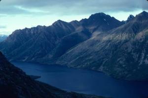
Kobuk River and Brooks Range, Alaska. Photo George Wuerthner
Linear features like roads also are used by predators like wolves. This can increase predator influence on prey like caribou. Roads and seismic lines in Alberta have led to increased predation on woodland caribou.
It also does not take much imagination to see that this road will eventually be extended to the coast by Kotzebue, fragmenting the entire western Brooks Range’s ecosystems.
Nevertheless, the road’s construction was approved by the Trump administration. However, the Biden Administration has ordered the Bureau of Land Management to reevaluate the Environmental Review.
The BLM accepted comments until November 4th. Whether the BLM review changes the decision to move forward with the road remains to be seen.
But my sources in Alaska say that the Biden Administration is likely to approve the road to help Alaskan politicians, perhaps with stricter regulations designed to address environmental concerns. The Biden Administration want to oppose new Democratic Congressional Representative Mary Petrola who is a supporter of the mine road. Murkowsi was critical to Democrats in voting to convict Donald Trump for his role in the Jan. 6th insurrection, was one of three GOP to vote for nomination of Judge Ketanji Brown Jackson and she was the only GOP member to support the Voting Rights Bill. Biden does not want to alienate her potential support for other Democratic agenda votes.
I can’t emphasize enough that this road is one of the biggest threats to the Arctic’s wildlands and wildlife. It is bigger than just the development impacts that may result from the Ambler Mining operations. I have no doubts that the road, if built, will eventually make other mineral and oil, and gas sources economically viable to develop.

Comments
Re Ambler road, see my facebook post (scroll down a bit):
https://www.facebook.com/boyd.norton
I’ve been following your posts for years now and you do an EXCELLENT job of analyzing and presenting good, reasoned information. Keep up the great work. BTW, I made a boat trip down the Kobuk from Ambler to Kayan (?)and I made a 12 day backpacking trip across the Brooks Range in 1976. The BP trip was up Koyuktuvuk Creek over Oolah Pass down the Itkillik River valley and over to Gailbraith Pipeline camp. I was with two Park Service planners, Ray Bane and John Kaufmann and also author Joe McGinniss. This trip was in what is now Gates of the Arctic National Park – and it was the most magnificent wilderness experience I’ve ever had in all my worldwide travels. This madness must be STOPPED!!
FYI – Doyon’s statement is that they are neither for or against the road. Their exact statement is: “Doyon lands as rights of way for the project. While we also do not oppose the road to Ambler, we have offered pointed criticism of both the project and its proponents in public comments.”
It should be noted that their main argument is that the road should come from Nome and that the state should be exploring “additional development outside of the Ambler Mining District.”. You can read their full statement here: https://www.akleg.gov/basis/get_documents.asp?session=30&docid=55058
Wow. Who knew that the so-called green electric vehicles would be the villain that ultimately brings mining to the areas in and around the Arctic Refuge!
We’re at the point where no matter what we do, it is a threat to the environment and wildlife.
Yes, I am afraid that green programs and trying to cure climate change will have many unanticipated brown effects. In the end will the green outweigh the brown? Well, I hope.
Yes. That’s for sure.
Right now I’m concerned about aggressive off-shore wind proposals and clashes with wildlife, ‘incidental take’ of marine life, and the world’s remaining 340 right whales as well!
This is to both Ida and Ralph, although hinted at by George.
One thing we learned during the planning and congressional phases for these Alaska parks and refuges:
The mineral vs wilderness issue IS NOT a zero-sum game.
You can mine were it makes the most sense, and preserve where it is essential.
Spending this much money to get to an area this remote to destroy the essential sheefish and caribou the local Native communities depend on has an alternative:
Mine copper where it is closer to the market and less destructive of wilderness species requiring incredibly pure water and low industrial intrusion.
Copper is widespread throughout the world and the lower 48, and closer to markets. When George says the ore here is “world” class, he is citing the copper not the cobalt.
Cobalt was suddenly made the issue when President Biden was trying to pass his first Infrastructure Bill. The very skillful Senator Murkowski inserted into Biden’s bill the brilliant scheme of requiring the removal of the ENTIRE larger body of the more common ore (copper)to get at the much smaller amount of cobalt.
We do not need to destroy NW Alaska and all these parks and wildlife refuges set up to protect our largest caribou herd, and wilderness rivers, and allow the continuation of our 10,000-year-old subsistence way of life on the edge between the Arctic and the SubArctic.
There is no such thing as “green” energy. This concept is nothing more than humans trying to have their cake and eat it too by living unnaturally and supposedly not harming the environment. This is childish fantasy. We either lower our population greatly and return to living simply & naturally — both long-term goals — or we continue killing and destroying. Read Bright Green Lies or see the film Planet of the humans for more details (the book is a lot better and clearer).
Using the phrase “the Ambler MINING District” is using a propaganda phrase, since none of the open pit copper mining has been permitted or started.
This is similar to the way, during the Reagan Administration, oil companies and refuge managers friendly to them, began to refer to the Arctic National Wildlife Refuge by its internal budget code: ANWR. In order for the nation to forget its purpose was as a wildlife refuge.
In this case, calling this almost entirely undeveloped area “mining district,” an area wedged between the Gates of the Arctic Wilderness, the Gates of the Arctic National Preserve, the Noatak National Preserve, the Gates of the Arctic National Park, and the Kobuk Valley National Park, is just a way to make us despair “this is a done deal !”
Destroying roadless Northwest Alaska is NOT a done deal.
Why is this area not included within all these adjacent parks? Because, before the lands could be frozen for congressional decision in the early 1970s, the State government slipped in under the deadline and “selected” the lands for ownership. The NPS team already had the area on their study area.
In fact, further back, in 1969 President Lyndon Johnson intended to create a national monument here, but did not in retaliation to his Secretary Stewart Udall stealing the moment by announcing it himself.
That was when this silly road route was announced by the State: as an effort to block Gates of the Arctic, not as a sensible road.
If intelligent design was your goal, you would follow the historic trails toward Ramparts, west of the Kanuti Wildlife Refuge, following ridges and stable ground.
No one has ever traveled any distance along this route in the summer, or anytime except when hard frozen. Spring or Summer? Forget it. No mining company has even walked it, much less designed crossings of all those rivers and streams.
No one could afford maintaining crossing hundreds of rivers and creeks with a gravel road unless they plan to declare bankruptcy and leave the frightening clean-up to the government.